
In-situ ocean observations are crucial for understanding the ocean system, improving the quality of weather and seasonal climate forecasts, ocean models and forecasts of the state of the ocean and its ecosystems, climate research, validating satellite data and assessing the impact of management strategies. In-situ observations are direct measurements of sea water properties made using a combination of sensors on a wide range of platforms that allow autonomous observations at sea, such as profiling floats, drifting buoys, gliders, moorings, instrument-tagged marine mammals, Ships of Opportunity including commercial ships and ferries.
Dedicated research vessels carrying out regular and repeated global surveys of the ocean are still the only method available for measuring the full suite of water properties of the deep ocean below 2000 meters and in ice-covered polar seas. Research vessels are also the only means available for discrete hand-sampling of water properties, ecosystem variables, and biological samples that are not yet automated. In coastal zones, regular and repeated surveys of coral reefs, mangroves, seagrasses, macroalgae, fish and marine life are carried out manually in national, regional, and globally-coordinated networks.
Only united worldwide effort can ensure a fit-for-purpose ocean observation system deployed by 2030
This vast network of in situ observations allow us to observe ocean variability at different scales at and below the surface of the ocean. Because the deployment and maintenance of ocean observing infrastructure is technically complex and costly, international collaboration and coordination are crucial to ensure global coverage, global data sharing, and interoperability of the many sensors and sampling methods that contribute to a global view. Only united worldwide effort can ensure a fit-for-purpose ocean observation system deployed by 2030 that is able to provide the measurements we need to address major societal challenges in support of the UN’s Decade of Ocean Science for Sustainable Development, the EU’s Green Deal objectives and other international and EU goals.
The EU is strongly committed to the development of a coordinated system of global in situ ocean observations, and has established and funds marine in situ infrastructures and the EU Copernicus in situ component.
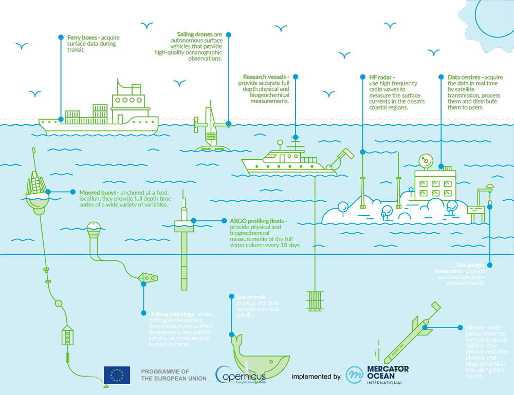
From profiling floats and research vessels, to buoys, tide gauges and even sensors on marine mammals, in situ observations are essential for operational oceanography. Credit: Copernicus Marine Service. For more information, click here.
European Marine Research Infrastructures
The European Commission, together with national funding, supports the development of marine Research Infrastructures (RIs) to conduct research and innovation and develop new technologies enhancing our marine environmental monitoring and prediction capabilities.
In the marine domain, RIs include specialised large-scale facilities encompassing instruments, vessels, data and services that cover wide scientific fields, in response to global marine challenges.
The following European RIs are contributing to sustained in situ global ocean observation. They have been or are being set up either as ERICs (European Research Infrastructure Consortia) with engagement at ministry level, or as AISBL (international non-profit organisation) with engagement at institute level.
![]()
The DANUBIUS-RI is to facilitate and contribute excellent science on the continuum from river source to sea; to offer state-of-the art research infrastructure; and to provide the integrated knowledge required to sustainably manage and protect River-Sea Systems. Its vision to achieve healthy River-Sea Systems and to advance their sustainable use, in order to live within the planet’s ecological limits by 2050.
 embrc.eu
The EMBRC ERIC provides access to marine biological resources, experimental facilities, training opportunities, e-services and technology platforms in its 45 marine stations in 7 EU countries, the UK and Israel to conduct marine biological research. It provides different users from academia, industry, technology and education with access to marine organisms and eco-systems and the facilities to study them.
 emso.eu
The EMSO ERIC consists in a system of regional facilities placed at key sites around Europe, from North East to the Atlantic, through the Mediterranean, to the Black Sea. Observatories are platforms equipped with multiple sensors, placed along the the water column and on the seafloor. They constantly measure different biogeochemical and physical parameters that address natural hazards, climate change and marine ecosystems. EMSO also offers data and services to a large and diverse group of users, from scientists and industries to institutions and policy makers
 www.euro-argo.eu
The Euro-Argo (ERIC) is the European contribution to the International Argo Programme that collects information from inside the ocean using a fleet of robotic instruments. Bringing together 25 organisations from 12 countries, Euro-Argo procures and deploys about 250 floats a year, enhancing the collective ability of the European nations to contribute to the global array while improving the coverage in sea areas of particular European interests.
 www.eurofleets.eu
The EuroFleets+ RI brings together key marine research actors (in particular research vessel operators) in Europe, North America and Oceania from 24 countries, facilitating transnational access to 27 research vessels, and multiple AUVs and ROVs from European and international partners.
 www.icos-cp.eu
The ICOS ERIC provides standardised and open data on levels of greenhouse gas emissions from more than 140 measurement stations across 12 European countries. The marine element of ICOS, the Ocean Thematic Centre provides long-term oceanic observations, which are required to understand the present state and better predict future behaviour of the global carbon cycle and climate-relevant gas emissions.
The ICOS Ocean Thematic Centre currently coordinates 21 ocean stations from 7 countries monitoring carbon uptake and fluxes in the North Atlantic, Nordic Seas, Baltic, and the Mediterranean Sea. Measuring methods include sampling from research vessels, moorings, buoys, and commercial vessels that have been equipped with state of the art carbonate system sensors.
 www.jerico-ri.eu
JERICO-RI is an integrated pan-European multidisciplinary and multiplatform research infrastructure dedicated to a holistic assessment of coastal marine system changes. It establishes the framework to observe, analyse, understand and forecast coastal marine systems for a better understanding of their functioning, and thus to a better assessment of their changes caused by the combined effects of natural and anthropogenic changes. JERICO-RI enables open-access to state-of-the-art and innovative facilities, resources, FAIR data and fit-for-purpose services, fostering international science collaboration.

The LifeWatch ERIC provides e-Science research facilities to scientists seeking to increase knowledge and deepen understanding of Biodiversity organisation and Ecosystem functions and services in order to support civil society in addressing key planetary challenges.
Copernicus In-Situ Component
 The Copernicus Programme is the European Union’s Earth Observation Programme and its services rely on data from in situ monitoring networks (e.g. ground based weather stations, ocean buoys and air quality monitoring networks) to provide robust integrated information and to calibrate and validate the data from satellites.
In situ data are an essential and integrated part of Copernicus, and are used extensively every day by the Copernicus services and the space component to produce products, and deliver services that are requested by end users. They are also used for the calibration and validation of satellite missions.
The European Environment Agency is leading work for Copernicus to catalogue the in situ requirements of the Copernicus services, which include the Marine Service, develop frameworks and pilot agreements to ensure access to all the relevant data in a timely and sustainable way.
The mission of the Copernicus In Situ Thematic Centre is to provide integrated in situ products built from in situ observations acquired from outside Copernicus Marine Service data providers (EU and international) to fit the needs of Copernicus Marine Service internal and external users.
It is a distributed centre composed of 6 regional centres working closely with the EuroGOOS ROOS (Regional Operational Observing System) and a Global centre well connected to the JCOMM networks (Joint WMO-IOC Commission for Oceanography and Marine Meteorology). INS TAC also works closely with the SeaDataNet infrastructure funded by the EU that coordinates a network of European National Data Centres which archive observation data acquired within scientific campaign and EMODNet, which is a network of organisations supported by the EU’s integrated maritime policy. Visit the “Share Ocean Data” page for more information.