With the coastal zone under increasing pressure from climate change and development, informed policy and management has never been more important. Thanks to the efforts of Copernicus and the European Marine Observation and Data Network (EMODnet), Earth observations from satellites and from sensors in the sea are helping decision-makers gather the evidence they need to create effective strategies.
Few environments are under as much pressure as those spanning the coastal zone. An estimated 40% of the World’s population lives within 100 kilometres of the coast. Development pressure is increasing on land and in the ocean. Combined with climate change-related threats such as sea level rise, increasing storm activity, and more intense storms, the need for evidence-based coastal management and planning has never been greater. Supporting those actions is a swathe of Earth Observations.
Earth observations from the sky
The EU Copernicus Programme has a long history of collecting Earth Observations. Thanks to the development of the Coastal Thematic Hub, accessing the data needed for coastal zone decision-making is about to get much easier.
“The objective of the Hub is to facilitate access to processed ocean data from all of the Copernicus Sentinel satellites and modelling systems as well as in situ ocean data from Copernicus’s services and entrusted entities relevant to the coastal zone,” Dr Muriel Lux, Environmental Policies and Key Account Manager at Mercator Ocean International, explains. “At the moment, the Hub is a proof concept. We’re going to start the test phase and collect feedback from users,” Lux says.
Alongside the Coastal Hub, Copernicus has also created a Marine Forum to facilitate discussion and co-design with EU member states, each with their national actions for the coastal zone and tools. “Some of these action plans and tools already use Copernicus services. Some don’t. Through the Marine Forum, we will learn how we can better support the member states and facilitate cooperation, and identify what data is missing,” says Lux, noting that the Hub will also support numerous European policies, such as the Marine Strategy Framework Directive, the Habitats and Birds Directives, and the Green Deal.
Indeed, the use cases for the Coastal Hub are many, ranging from tsunami risk assessments in southern Italy to Earth Observation services for wild fisheries, oyster ground restoration and bivalve mariculture along European coasts. These use cases rely on data from Copernicus’s atmosphere, climate change, emergency, land, and marine services. Some projects, like the PLASMAR maritime spatial planning project, showcase the importance of other data, namely in-situ data made available through the Copernicus Marine Service in situ thematic assembly centre and the European Marine Observation and Data Network (EMODnet).

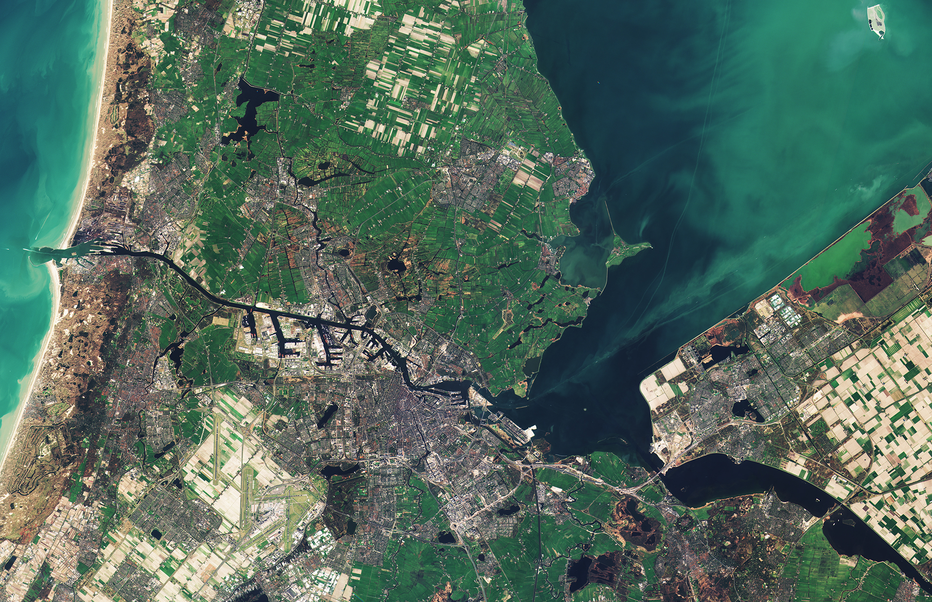
Copernicus Sentinel-2B satellite takes us over part of the western Netherlands on 16 March, with the capital city of Amsterdam at the centre of the image. Contains modified Copernicus Sentinel data (2017), processed by ESA, CC BY-SA 3.0 IGO
Earth observations from the sea
EMODnet specialises in the wider in-situ data collection efforts that are often complex, taken in delayed mode and require a high effort in data curation. “EMODnet started about ten years ago in response to the European Union’s recognition that society needed marine knowledge and yet despite many stakeholders collecting marine data, many of these data were not being made publicly available, and often distributed across sector-specific repositories and in unharmonised formats, making data discovery and access very challenging,” says Dr Kate Larkin, Head of the EMODnet Secretariat.
Today, EMODnet provides an operational EU public data service for in-situ marine data gathered from hundreds of data collection efforts under seven broad themes – bathymetry, biology, chemistry, geology, human activities, physics, and seabed habitats. The diversity of data is vast, with tens to hundreds of parameters for each thematic. EMODnet’s Biology theme, for example, ranges from phytoplankton to marine mammals. “It may be that data are collected with autonomous samplers for phytoplankton, but when we’re getting up to marine mammals, we’re talking tagging or human observer data,” Larkin explains.
EMODnet also creates data products, including composite maps spanning marine litter to vessel density, and the flagship Digital Terrain Bathymetry and EUSeaMap for Seabed Habitats. Like Copernicus’s products, EMODnet’s data and data products support numerous regional, EU and international policies concerning the coastal zone. For example, the seabed habitat data supported the classification of European IUCN Red Listed Marine Habitats, and the Helsinki Commission (HELCOM) used EMODnet Chemistry as a platform to manage Baltic Sea beach litter data. “You need these diverse datasets [to guide policy and decision-making], but it’s impossible for one stakeholder group to gather everything it needs. This is the beauty of sharing data and then standardising it, to collect once and make it usable many times for multiple purposes,” says Larkin, adding that harmonising data also helps reveal what data is missing and from where.

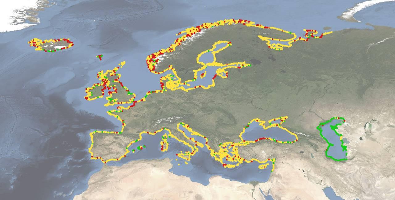
Pan-European overview map of shoreline migration (red = landward; yellow = stable; green = seaward). EMODnet Geology Portal.
Guiding coastal zone policy
Copernicus and EMODnet work closely together. From an operational perspective, “Copernicus Marine integrates many satellite and in situ data into the modelling systems. This observation data is also used for the quality control processing,” explains Lux. “In addition to operational data flows and dialogue in a newly formed Marine In Situ Coordination group, we also have coordination meetings, so we can exchange on what the two services offer, their evolution and common areas of interest, which includes the coastal zone, making sure that the two EU marine data services Copernicus Marine Service and EMODnet add value to each other,” says Larkin. The two also work closely on projects, with a prime example being the EDITO-Infra project, which will create the operational core of the European Digital Twin of the Ocean, which will include, among other components, a common data lake of EMODnet and Copernicus Marine Service data and data products that are interoperable and usable.
Both Lux and Larkin stress that a combination of both in-situ and satellite-derived observations and model products is essential for informed decision-making about coastal zone activities. “We both work very closely with our users to understand which data and products are used and which are needed,” says Larkin, adding that long-term funding for data collection and data services like EMODnet and Copernicus “is vital for achieving policy goals, like the EU Mission: Restore our Ocean and Waters.”
Experts from EMODnet and Copernicus Marine Service also take part in GEO Blue Planet’s working group on coastal geomorphology. The working group works with different stakeholders to identify the needs and the gaps in coastal and marine data availability and knowledge sharing for the coastal communities, with the scope of near shore and offshore mapping (bathymetry and coastal erosion/accretion, coastal inundations, etc.) and the development of early warning systems for coastal hazards management.
Read more:
- More use cases from the Copernicus Coastal Hub: https://www.coastal.hub.copernicus.eu/use-cases
- More use cases from EMODnet: https://emodnet.ec.europa.eu/en/use-cases
- GEO Blue Planet workshop on Ocean observation and prediction to support coastal sustainability and resilience in Africa
- GEO Blue Planet working group on coastal geomorphology


