The Global Monitoring for Environment and Security and Africa (GMES and Africa) is a joint programme of the European Commission and the African Union Commission. It serves to strengthen and further develop infrastructure for a more coherent exploitation of Earth Observation data (space and in-situ), technologies and services in support of the environmental policies for sustainable development in Africa and African, Caribbean and Pacific Group of States.
Initial phase | 2017 – 2021
A successful initial phase ran from 2017 to 2021 implemented by 12 Consortia, involving 122 institutions – almost all from Africa – and 51 countries.
- See achievements of phase one on GMES and Africa blog
- See some flagship projects developed under phase I highlighted by the Copernicus Observer
Phase two | 2022-2025
Kicked-off in early 2022, the GMES and Africa phase two is currently underway, running to 2025, with an initial investment of EUR 24.65 million from the European Union.
Phase two awarded eight consortia across the African continent with grants to foster and catalyse the development of African-driven Earth Observation (EO) services and applications tailored to African needs at continental, regional and local levels. The consortia will work alongside African organisations, policymakers and practitioners, and in cooperation with the Copernicus Earth Observation Programme, the European Space Agency and EUMETSAT, to make more effective use of EO products towards sustainable management of natural resources and strengthened mitigation and adaption options in the face of climate change.
GMES and Africa will continue to cover the two thematic areas of the initial phase i) water & natural resources and ii) marine & coastal areas. Through the grants, the consortia will address the needs of operational information services in Africa covering the entire value chain: from increasing access to information and development and provision of services, to enhancing engagement and capacity of users and ensuring utilisation of these services.
The second phase of the programme also introduces a strong component on women and youth, with the decision to include 30% of women specialised in EO-related fields as part of the consortia teams.
Consortia under Marine and Coastal Operations Thematic Area (phase II)
Marine and Coastal Operations for Southern Africa and the Indian Ocean
Consortium partners: Council for Scientific and Industrial Research (CSIR) (lead), ABALOBI, Benguela Current Convention, Coastal Oceans Research and Development Indian Ocean – East Africa, Institut Halieutique et des Sciences Marines, University of Dar es Salaam, Kenya Marine Fisheries Research Institute, Mauritius Oceanography Institute, National Sea Rescue Institute, Tanzania Fisheries and Research Institute, University of Eduardo Mondlane, WIOMSA
Services: Fisheries and Aquaculture, Coastal Monitoring (ecosystem, coral bleaching), and Marine and Maritime Service (ship traffic, safety at sea)
Earth Observation to Support Marine And Coastal Areas Management in North and West Africa
Consortium partners: University of Ghana (lead), Nigerian Institute for Oceanography and Marine Research, Centre for Oceanographic Research of Dakar-Thiaroye, Institut de Recherches Halieutiques et Océanologiques du Bénin, Wetlands International Africa, Institut National de Développement des Pêches, The Ghana Meteorological Agency, Centre Universitaire de Recherche d’Application en Télédétection.
Services: Ocean monitoring, safety at sea, fisheries (IUU, potential fishing zones), costal monitoring & mapping, oil spill monitoring
Consortia under Marine and Coastal Operations Thematic Area
(Phase I: 2016 – 2021)
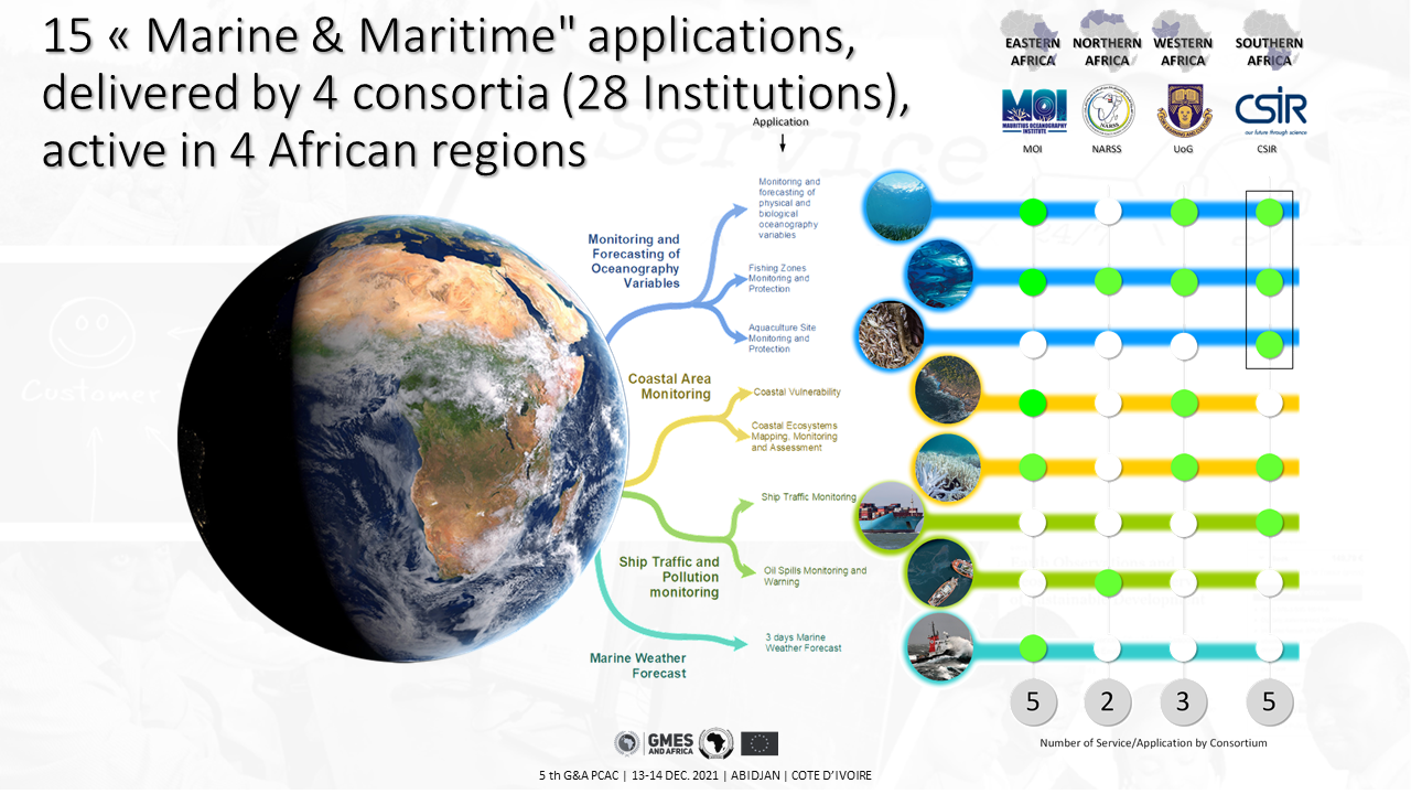
GMES and Africa applications related to Marine and Coastal Resources Management. @GMES and Africa
Dr. Tidiane Ouattara, GMES & Africa Coordinator presents how the Copernicus Marine Service supports GMES & Africa programme
Useful Links
- Blog of GMES and Africa Programme Management Unit
- GMES and Africa on African Union Commission website
- GMES & Africa Selects Eight Consortia at the Award and Kick-off Ceremony for 2nd Phase – Space in Africa (africanews.space)
- GMES and Africa phase 1 results
- Copernicus Observer: GMES&Africa: Unlocking power of EO data in Africa with Copernicus
- EU4OceanObs news post: GMES & Africa: increasing use of EO data for sustainable development in Africa
- Copernicus Marine #OceanChallenge4Africa Hackathon April 2022
- EU4OceanObs | European intiatives to enhance collection, access and use of ocean observations for sustainable development in Africa


