The European Commission is committed to fostering Europe-Africa cooperation as part of its strategy to enhance the collection, sharing and use of global ocean observations to address societal challenges. With new political opportunities and technological advances, strengthened cooperation in this domain between the two continents is paramount for achieving the UN Ocean Decade outcomes, the UN Sustainable Development Goals (particularly SDG 14), and a global digital and green deal.

The Blue Economy offers huge potential for economic growth, diversification, and development, and information derived from Earth observation plays a critical role in managing marine and coastal resources in Africa. Launched in 2014, the Global Monitoring for Environment and Security and Africa programme (GMES and Africa) is the main vehicle of Europe-Africa cooperation on Earth observation and data processing systems, and their applications in a user-driven approach. Building on existing Earth observation programmes and infrastructures such as Copernicus, GMES and Africa focuses on developing African Earth observation capacities in several key areas, including management of marine and coastal areas and resources.

With  more  than  35,000  km  of  coastline,  coastal  and marine  environments  play  a  vital  role  in  the  socio-economy  of  many  African  countries,  contributing  significantly  to  income, food security, trade, transport, energy and supporting a wide range of coastal livelihoods

As a step to renew and strengthen the Europea-Africa Space cooperation, the Europe-Africa Space Earth Observation Forum took place in June 2021 under the Portuguese Presidency of the Council of the European Union. With the theme ‘Space as an enabler for digital and green transitions, with Earth observation fostering sustainable development, new skills and job creation”, this high-event aimed to foster European-African cooperation on advanced Earth observation and data processing systems and their applications in a user-driven approach.

To expand the global monitoring and forecasting capacities, and increase the use of ocean and coastal observations to address environemental and socio-economic challenges in Africa, EU funds or partly funds the following infrastructures, programmes and projects:

Global Monitoring for Environment and Security and Africa programme (GMEs and Africa) is the main vehicle of Europe-Africa cooperation on Earth observation and data processing systems, and their applications in a user-driven approach. Click here for more information.

All Copernicus Services provide data and services catering to the needs of various marine and coastal stakeholders in Africa.

Marine Servicemarine.copernicus.eu : provide free access to global observation products (in situ and satellite) and modeling data for the physical ocean (waves, sea level, currents, temperature, salinity….), the biogeochemical ocean (nutrients, chlorophyll, plankton, ocean colour…) for the global ocean. Regular dedicated trainings and e-learning materials are provided for users of ocean and coastal data working in Africa (See training and learning materials on #Marinedata4Africa event held in Dec 2021 and the #OceanChallenge4Africa Hackathon April 2022)

Climate Change Serviceclimate.copernicus.eu : provides free data and information about the past, present and future climate, as well as tools to enable climate change mitigation and adaptation strategies by policy makers and businesses worldwide. The Service distributes ocean climate products from two sources: satellite observations and numerical model reanalysis or seasonal forecast. Visit the climate data store – climate.copernicus.eu/climate-data-store

DIAS WEkEO platform – www.wekeo.eu provides access to all Copernicus datasets (including data from EUMETSAT and Copernicus Marine Service) and cloud-based processing environment.

Land Monitoring Serviceland.copernicus.eu : provides a series of bio-geophysical products on the status and evolution of the land surface at global scale at mid and low spatial resolution. The products are used to monitor the vegetation, the water cycle, the energy budget and the terrestrial cryosphere.

Emergency Serviceemergency.copernicus.eu: supports all actors involved in the management of natural or manmade disasters by providing geospatial data and images for informed decision making. To access data on mapping, flooding, droughts, wildfires and drought, click here.

EMODnet is a network of over 120 organisations that collectively assemble, standardise, harmonise and integrate in situ marine data from diverse data providers across seven discipline-based themes: bathymetry, geology, sea habitats, chemistry, biology, physics, and human activities. The EMODnet Central Portal offers a gateway to the wide range of data and added value data products e.g. basin-scale maps, some with predictive capability, for each theme. Visit EMODnet’s data portal overview and also resources for Atlantic Stakeholders access to data & products.

The European Space Agency’s African Framework for Research, Innovation, Communities and Applications – building an African-European R&D partnership (EO Africa) fosters an African-European R&D partnership, facilitating the sustainable adoption of the Earth Observation and related space technology in Africa.

The European Copernicus programme and the Earth observations collected by its Sentinel satellites offer unprecedented open and free data amounting up to 1.2 petabytes per year over the African continent. The vast amount of free data to be processed and analysed requires adoption of the latest digital tools such as cloud computing and innovative machine learning techniques. This will enable full EO data access and usage across Africa, overcoming low-bandwidth and infrastructure bottlenecks that still persist across the continent.

EO AFRICA is driven by African user needs and follows a long-term vision (>10 years) for the emergent digital era in Africa. It builds on 17 years of experience gained through the ESA TIGER initiative and its African network of EO experts, and aims to facilitate the sustainable adoption of Earth Observation and related space technology in Africa.

For more information, click here.

EUMETSAT made the support of Africa a strategic objective, combining its efforts with the European Union, the African Union and the World Meteorological Organizsation (WMO). A number of projects and initiatives have already taken place to help the African meteorological community meet its national and regional requirements in terms of severe weather warnings, water and agriculture management, and mitigation of the effects of natural hazards and climate change. For more information, click here.

EUMETSAT organised a series of webinars “Earth Observation in Africa” 2021, in partnership with the GMES & Africa progamme, including a dedicated webinar to increase awareness of the role of Earth observation satellites in supporting African Blue Economy strategy (Earth observation for Marine applications in Africa, Dec 2021)

As an informal group of space agencies and international organisations, including ESA and a number of European national space agencies, the Space Climate Observatory (SCO) International Initiative addresses the need to step up international coordination for accurate assessment and monitoring of the consequences of climate change from observations and numerical models.

Projects in Africa steered by European SCO members

OSS Saint Louis: This project concerns the Saint-Louis coastline, which is particularly vulnerable to coastal erosion and flooding. The aim is to acquire more information, to raise awareness among all players of the hazards and risks posed to coastal areas as a result of climate change, and to develop tools and indicators relating to the vulnerability of the local population and economic activities. Click here to learn more.

Mangroves Madagascar: The need to understand and monitor mangrove forests continues to be a priority: it involves organising the management of their natural resources, characterising the relationships between global change and the state of their local environments and ensuring their conservation. Using Copernicus and THRS data, the project’s objective is to support institutional stakeholders in charge of Mangroves. Click here to learn more.

Through its funding programmes for Research and Innovation (H2020 and its successor Horizon Europe), the European Union funds ocean research projects that work to expand the global monitoring and forecasting capacities, and increase the use of ocean and coastal observations to address environemental and socio-economic challenges in Africa. These include, among others:

  • Triatlas (triatlas.w.uib.no): Tropical and South Atlantic climate-based marine ecosystem prediction for sustainable management
  • AtlantECO (www.atlanteco.eu): aims to develop and apply a novel, unifying framework that provides knowledge-based resources for a better understanding and management of the Atlantic Ocean and its ecosystem services, bringing together experts and pioneers from Europe, South America and South Africa with the relevant resources, knowledge and experience.
  • R&I projects dedicated to the Atlantic ocean, relevant for African countries bordering the Atlantic, full list available here.
Sea Surface Height above geoid on MyOcean Viewer. Copernicus Marine Service.

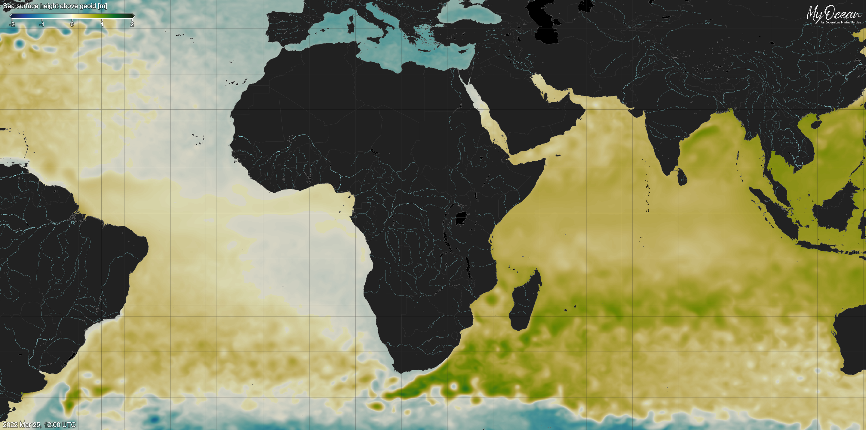
Sea Surface Height above geoid on MyOcean Viewer. To access data product on Copernicus Marine, click here.